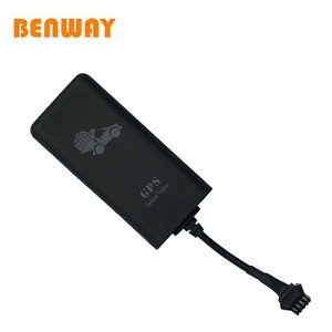
🚀 Bonrix Unveils Next-Gen Vehicle Tracking Dashboard: Smarter. Faster. More Connected. 🚘🌍
At Bonrix Software Systems, Ahmedabad, Gujarat (India), we’ve always believed that innovation drives progress. For over two decades, we’ve pioneered cutting-edge IT solutions—from GPS tracking to fintech, AI/ML, and beyond. Today, we’re thrilled to redefine fleet management with our new-generation Vehicle Tracking Solutions Dashboard, designed to empower businesses with real-time intelligence, multi-map precision, and unmatched scalability.
Why This Dashboard Changes the Game for Fleet Management
Managing a fleet shouldn’t feel like herding cats. Our dashboard simplifies complexity with features tailored for modern logistics, transportation, and delivery ecosystems:
- 📍 Unified Fleet Monitoring: Track every vehicle in real time—no matter the size or scale.
- 🗺️ Multi-Map Precision: Switch between Google Maps, OLA Maps, and MapMyIndia for hyper-localized tracking.
- 🌐 Multilingual Accessibility: Supports Hindi, Gujarati, Marathi, Bengali, and more.
- ⚙️ Vehicle Add-On Insights + Live Weather: Monitor fuel levels, engine diagnostics, maintenance alerts, and real-time weather conditions.
- 📊 Advanced Reporting & Analytics: Turn raw data into actionable insights with customizable reports and historical analysis.
Built for Businesses That Demand Excellence
Whether you're managing a startup’s delivery fleet or an enterprise’s pan-India logistics network, Bonrix’s dashboard adapts to your needs. Our integration of IoT, cloud computing, and AI-driven analytics ensures your operations stay agile, cost-efficient, and future-ready.
Why Bonrix Stands Out
- Proven Expertise: 20+ years of delivering reliable GPS tracking solutions.
- Local + Global Vision: Designed for Indian terrains but built with global tech standards.
- End-to-End Ecosystem: From QR-based payments to AI chatbots, we offer solutions that grow with your business.
Ready to Transform Your Fleet Management?
Let’s drive smarter, together. 🚀
| Login Details | Credentials | Web Link |
|---|---|---|
| Website Link |
http://fleet.tracker24.in/
username - ccpl password - 654321 Mobile No. is mandatory |

|
×
![Modal Image]()
🚗 Dashboard Overview
This is the main screen of a web-based application, likely a Fleet Management System (FMS). The top navigation bar indicates the key features: Dashboard, Devices, Tracking, Reports, and Alerts. The user is currently on the Dashboard view.
🌐 Geo-Fence Creation and Management
This screen is dedicated to defining geo-fences, which are crucial for automated monitoring and alerting in fleet management. The large circle overlaying the map around Gurugram represents a newly drawn or selected geo-fence. This indicates that the system supports drawing circular fences, a common type.
📍 POI Management Description
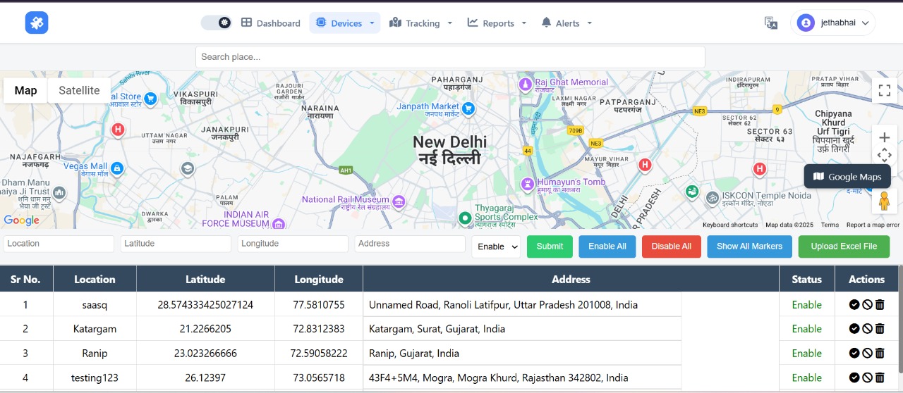
This screen is accessed via the Devices or a related management menu, distinct from the main Dashboard. Its purpose is to allow the user to define, view, and manage important geographic locations.
Geo-Path Drawing and Route
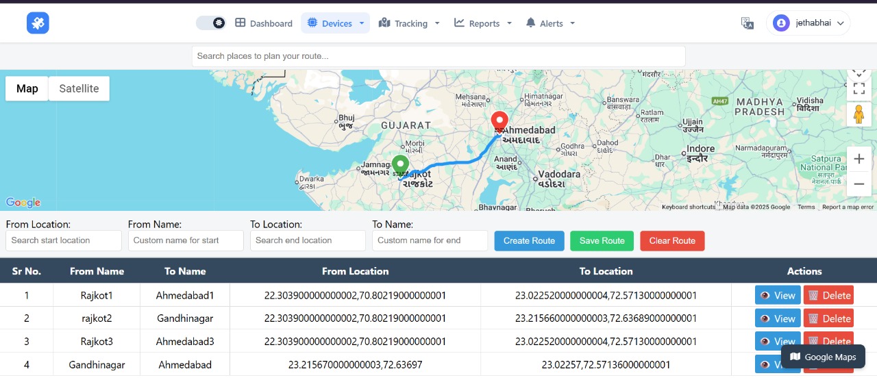
This screen is your Geo-Path Drawing and Route Management interface within the GPS dashboard, primarily used for planning, visualizing, and storing authorized or optimized travel paths for your fleet.
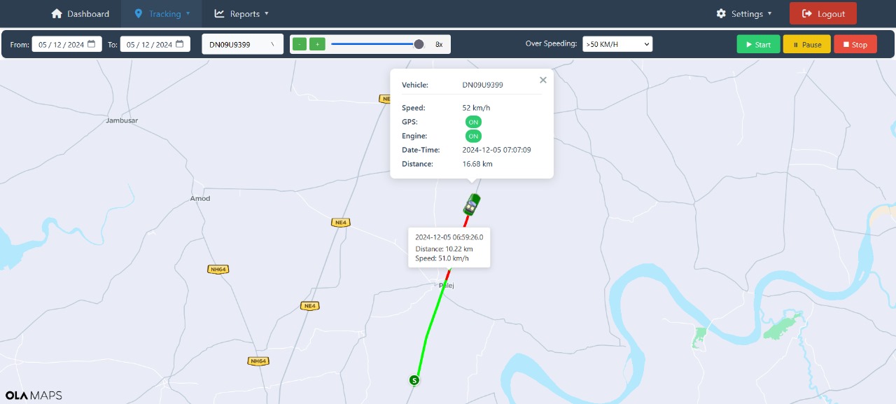
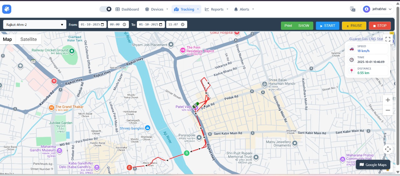
🗺️ Live Tracking Description
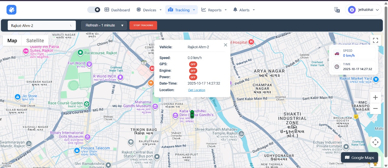
The screen is centered on a detailed map, currently focused on the city of Rajkot. The map shows a clear route line, indicating the path recently traveled by the selected vehicle.
🎥 Playback Tracking Description
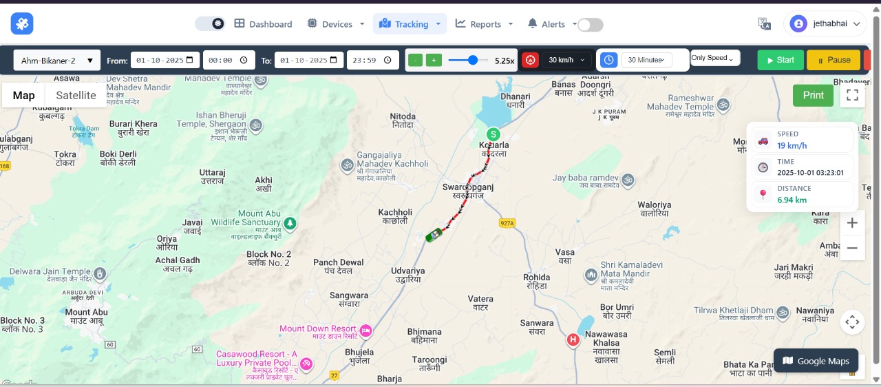
The screen is set up to virtually recreate the route taken by a vehicle, providing a powerful auditing tool. Vehicle and Time Selection: The vehicle selected for review is "Ahm-Bikaner-2".
Drweble/Route Deviation Visualization
The core focus of this screen is to show the actual path taken by the vehicle and potentially highlight areas where the vehicle deviated from a planned path (a drweble or drawing capability) or where specific events occurred.
🛣️ Multi-Vehicle Path Visualization
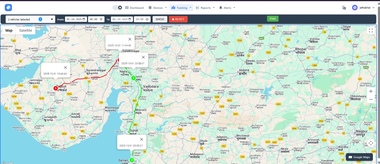
This screen allows the user to display the historical routes of multiple vehicles simultaneously on the same map for comparative analysis. Vehicle Selection: The top left confirms that 2 Vehicles Selected are being tracked in this session.
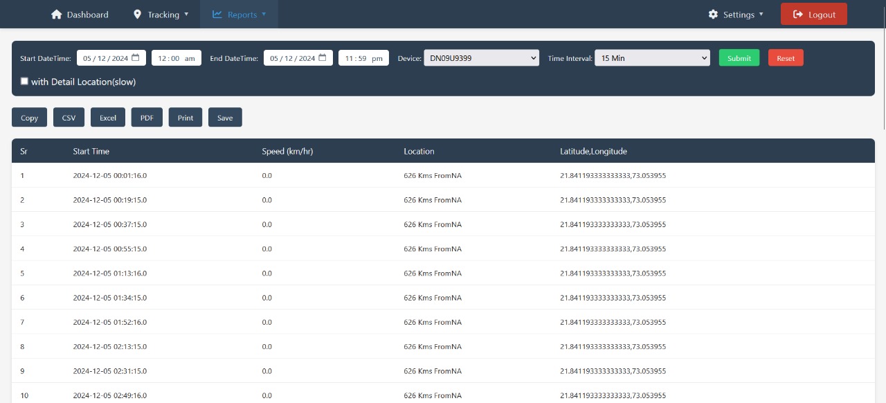
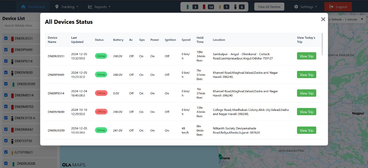
📊 GPS Vehicle History Report – Detailed Activity Log for Fleet Oversight
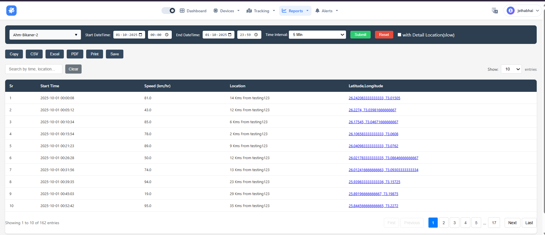
This report provides a time-stamped, detailed log of a vehicle’s historical activity—including location, speed, and event types (e.g., trip start, stop, idling)—enabling fleet managers to verify routes, monitor driving behavior, and ensure compliance with policies and regulations. It supports operational efficiency, safety audits, and accountability through precise GPS-derived data.
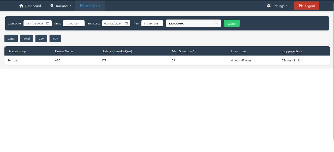
Fleet Summary Report
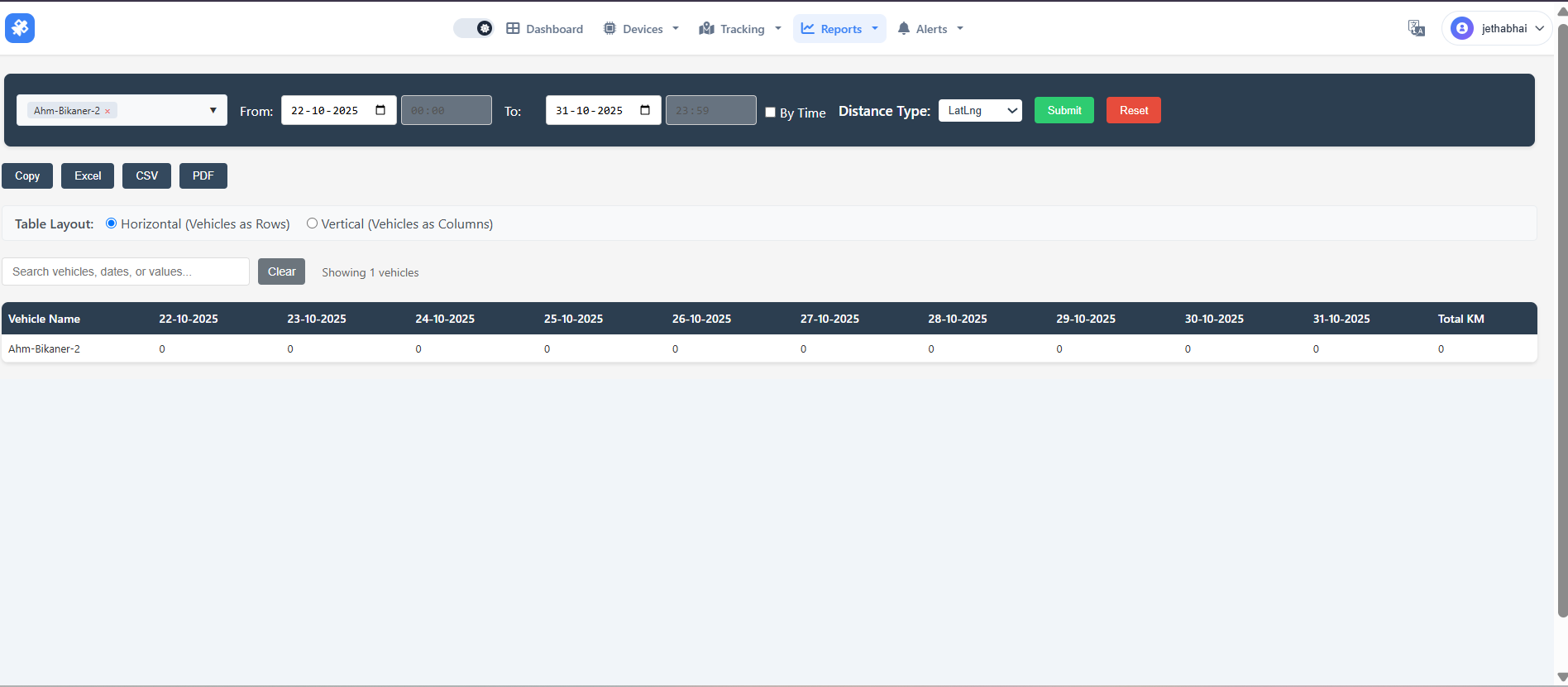
The Fleet Summary Report provides a daily breakdown of kilometers traveled by a selected vehicle ("Ahm Bikaner-2") over a specified date range (22–31 October 2025), showing 0 km driven each day for a total of 0 km. The interface includes filtering options, layout toggles, and export features (Excel, CSV, PDF) for data analysis and sharing.
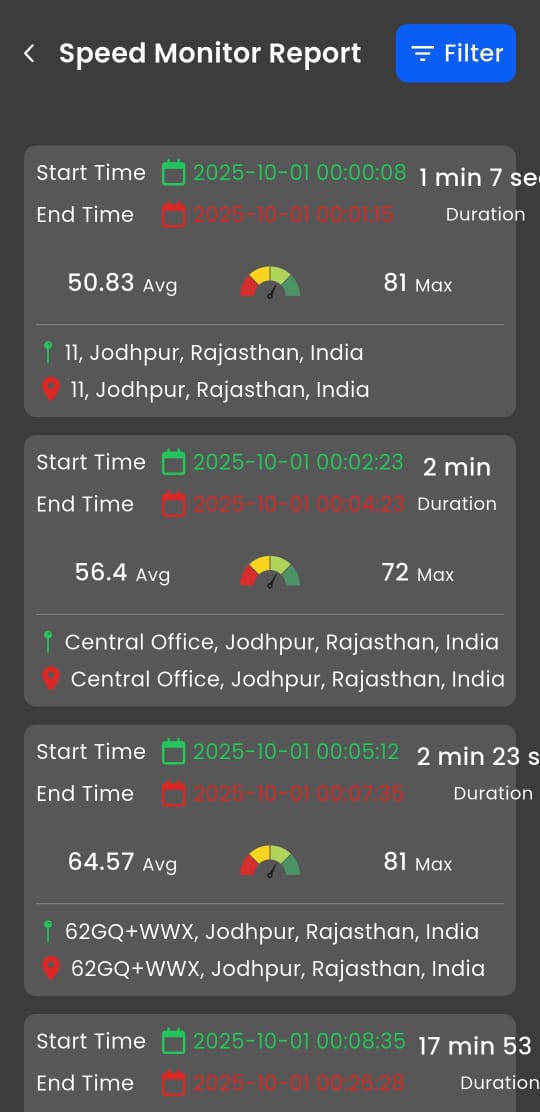
🚦 Speed Monitoring and Trip History Reports
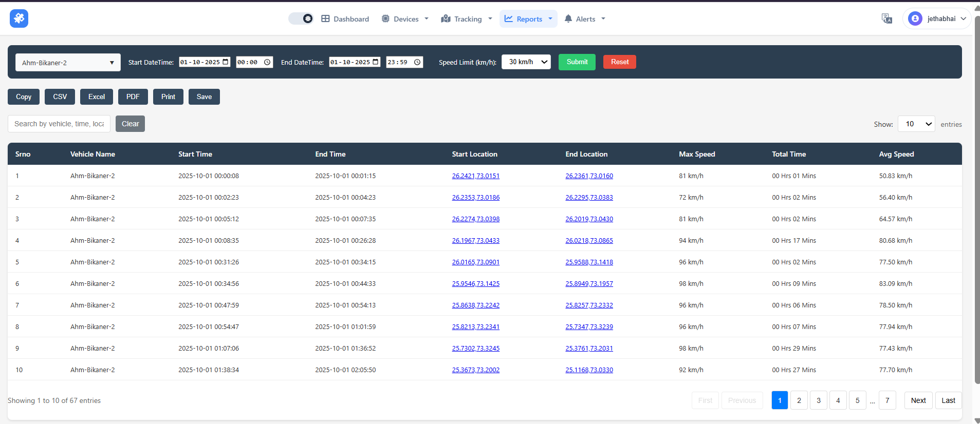
The system provides two complementary reports for vehicle "Ahm-Bikaner-2" on 01-10-2025: a detailed speed log with second-by-second location and speed data for forensic analysis, and a trip summary showing aggregated journey metrics like max speed, duration, and start/end points. Together, they enable effective driver behavior monitoring, safety enforcement, and operational efficiency tracking.
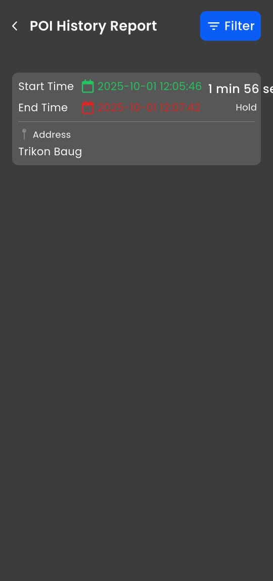
📍 POI History Report
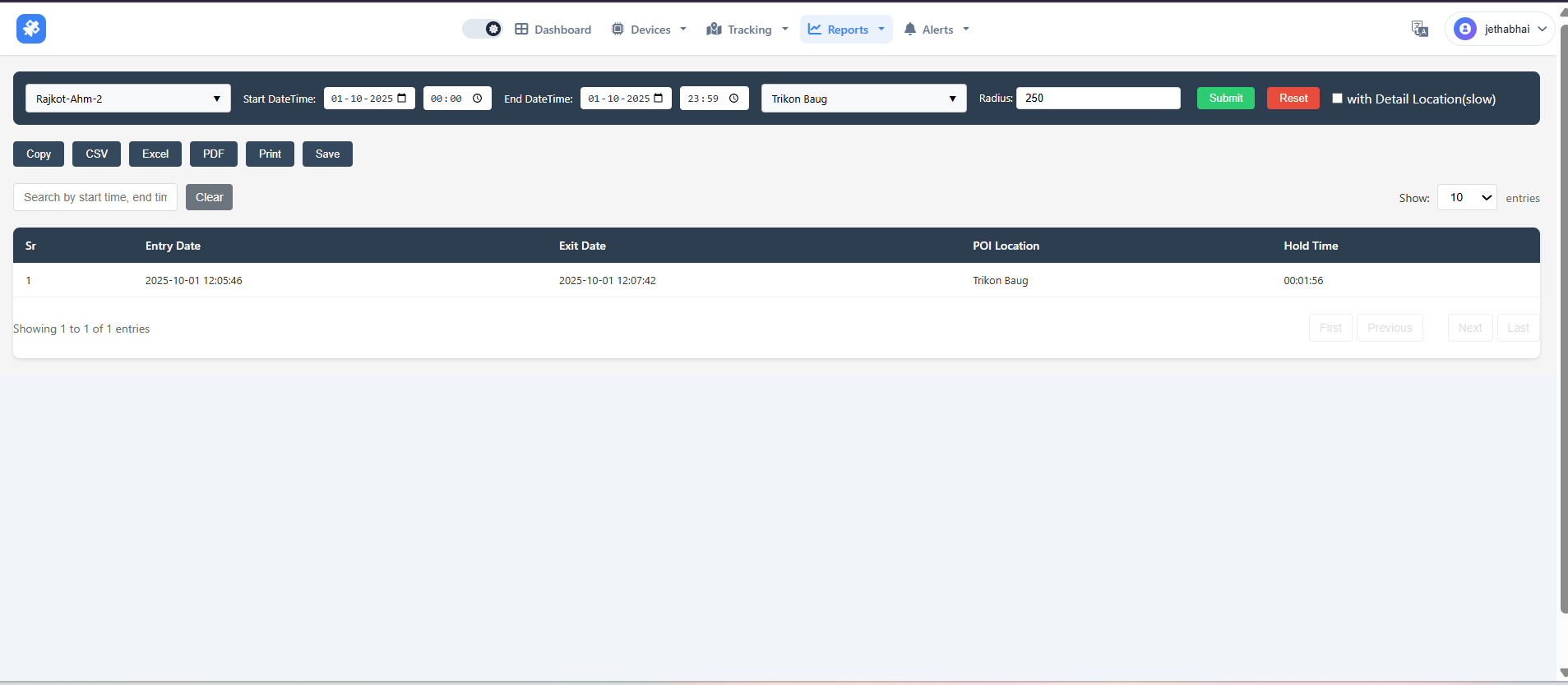
The POI History Report logs every entry and exit of a vehicle at predefined Points of Interest (e.g., warehouses, client sites), showing timestamps, duration of stay (Hold Time), and entry/exit speeds. It enables service verification, operational efficiency analysis, and compliance auditing by tracking exactly when and how long a vehicle was at key business locations.
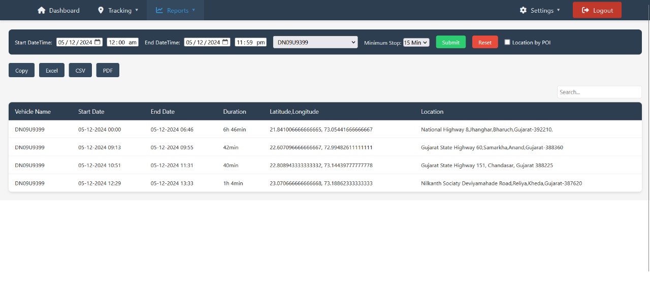
🛑 Stoppage Report
To provide a clear, auditable log of all stops made by a vehicle during a selected period. This is essential for controlling fleet operations, improving efficiency, and ensuring accountability.
📊 Key Fleet Management Reports for Operational Oversight and Compliance
The page offers a suite of essential reports: Trip Summary for journey overviews, Detailed Trip Report for speed analysis, Activity/Speed Report for minute-by-minute incident investigation, Stoppage Report to identify inefficiencies from prolonged halts, and POI History Report to verify visits and dwell times at designated locations like Trikon Baug—enabling comprehensive fleet monitoring, efficiency optimization, and compliance validation.
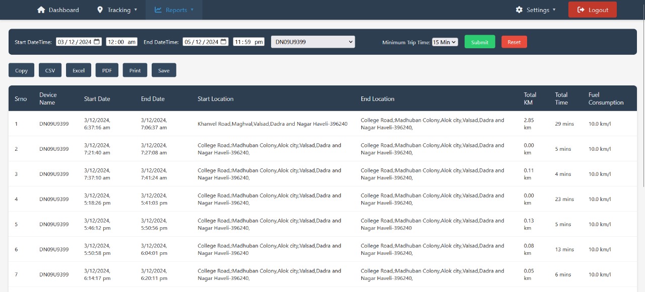
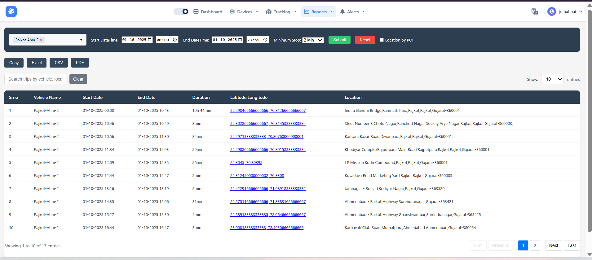
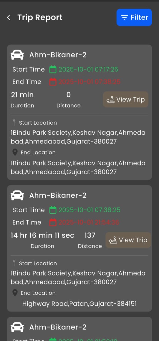
Trip Summary Report
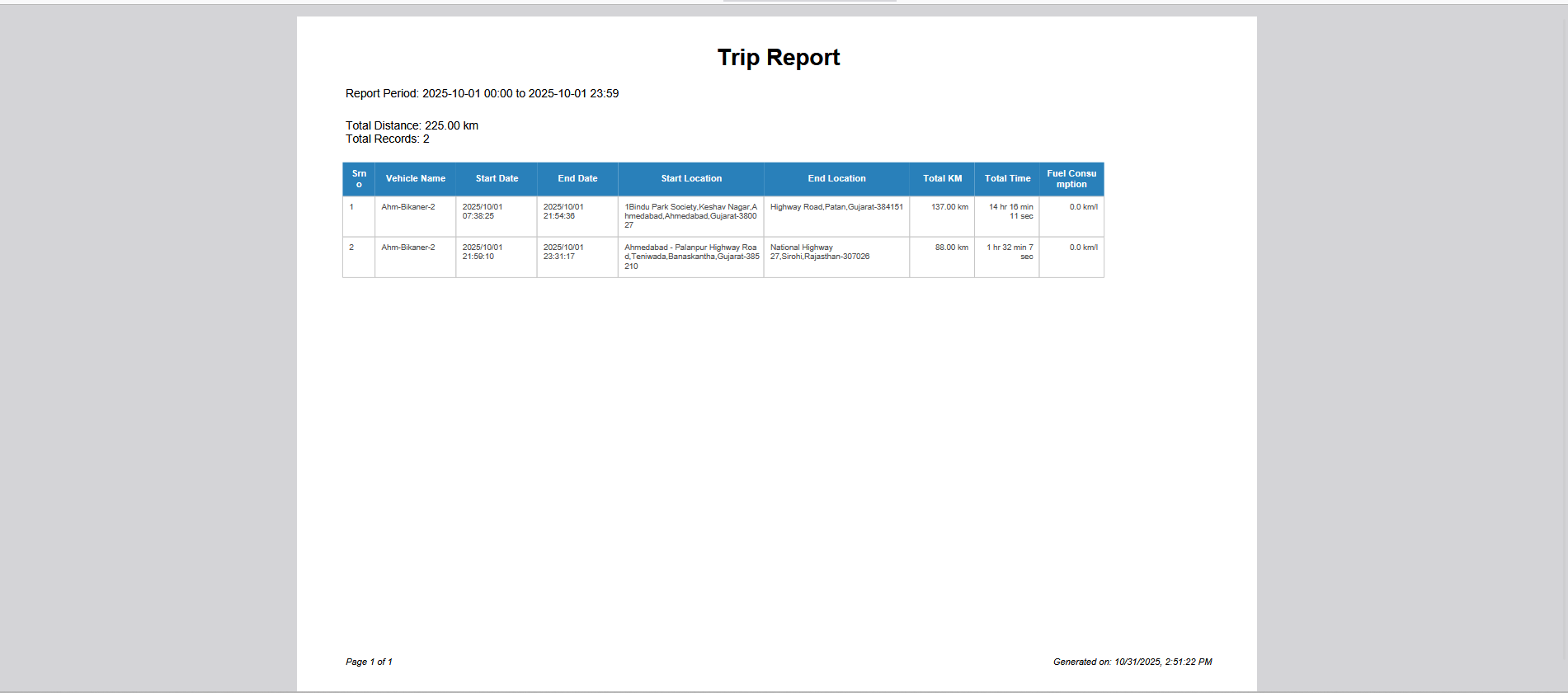
This is a clean, printable summary report for the trips taken by the vehicle Ahm-Bikaner-2 on October 1, 2025. This view is designed for formal use, such as sharing with management or for record-keeping.
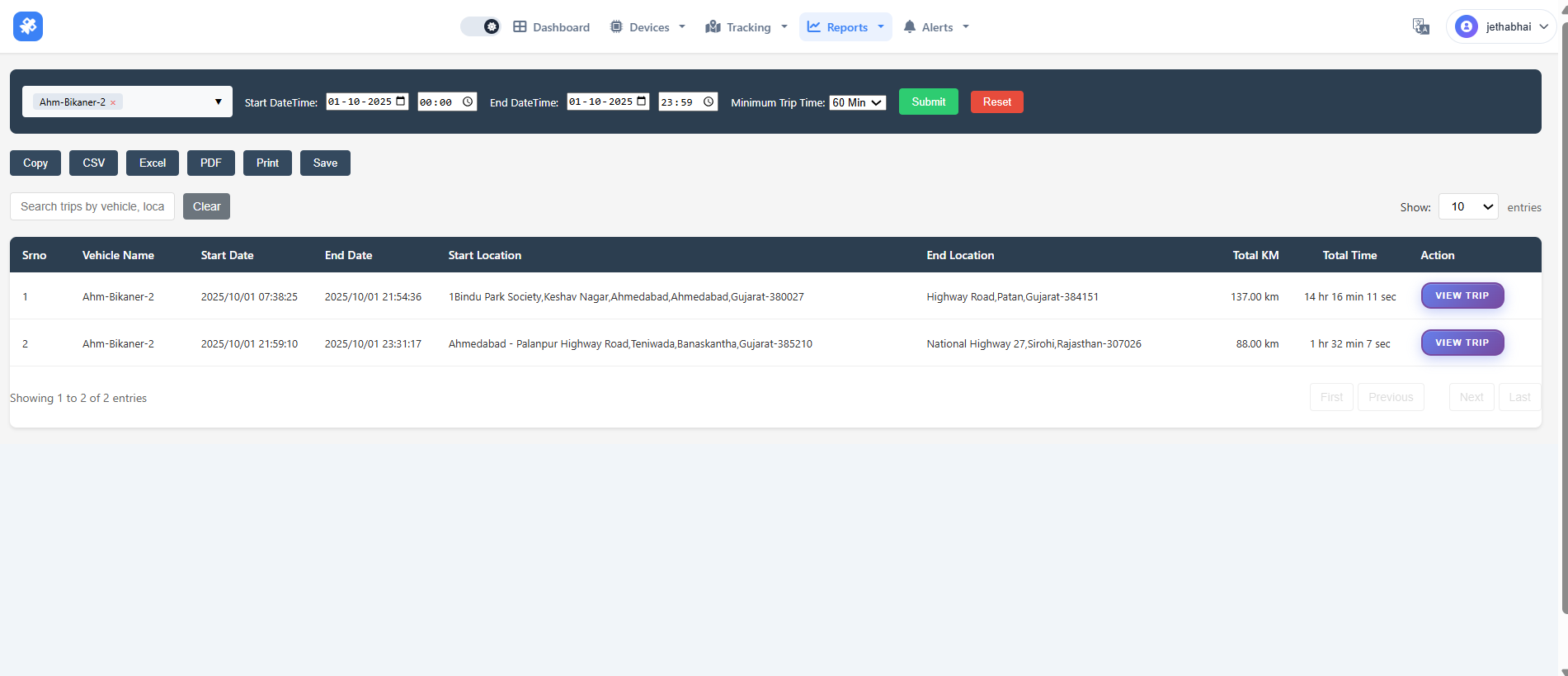
📝 Trip Report
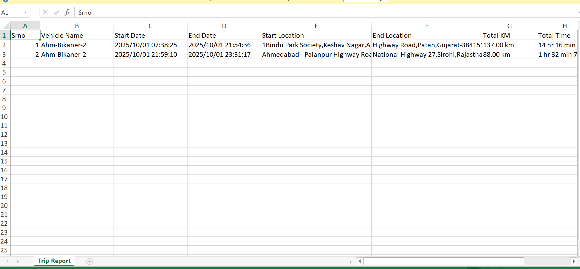
📝 Trip Report (Excel File Description) This file is an organized, tabular record of the main journeys completed by the vehicle Ahm-Bikaner-2 on the selected date (2025/10/01). The Excel format makes it easy to sort, filter, and perform further analysis on the data.
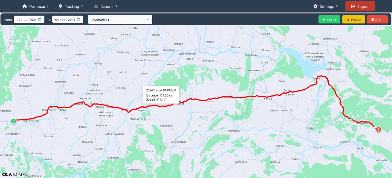
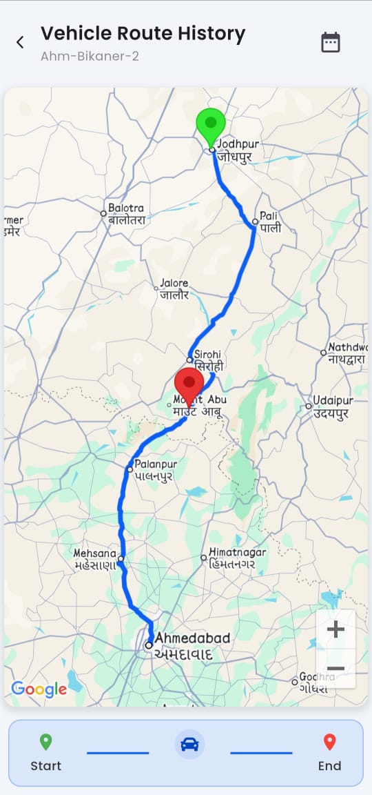
Vehicle Route History (Map View)
Visualizes the complete journey from Ahmedabad to Jodhpur with labeled waypoints and start/end pins for route verification and audit.
Input History Report
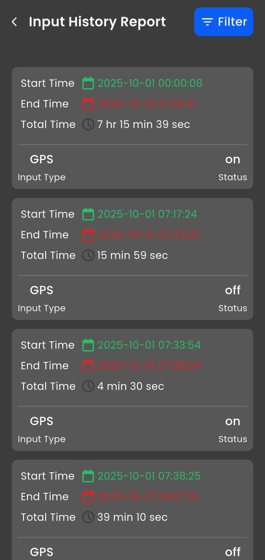
Logs GPS device power/input status to detect tampering, disconnections, or signal gaps with precise on/off durations.
Live Tracker Menu
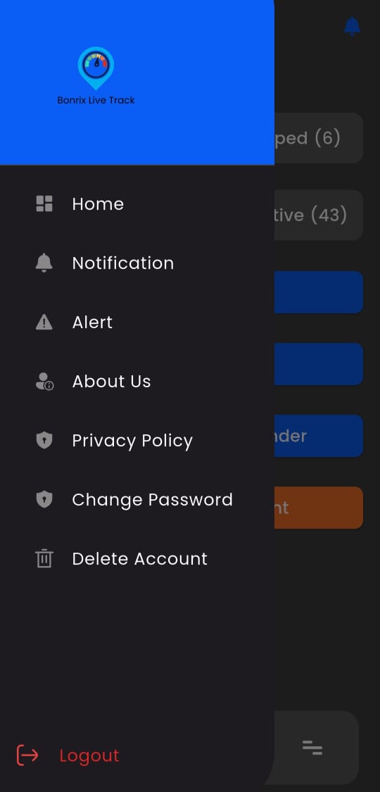
Central navigation hub providing quick access to monitoring, reports, settings, and vehicle control features.
Settings
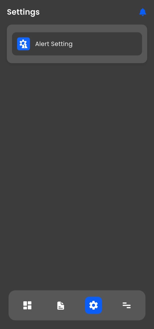
Configure user preferences, notification rules, map defaults, and system behavior for a personalized tracking experience.
About Us
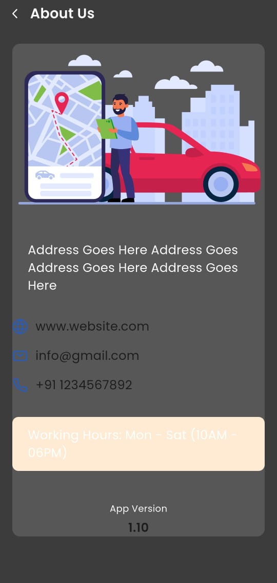
Displays company information, app version, and support details for transparency and user assistance.
Alert Settings
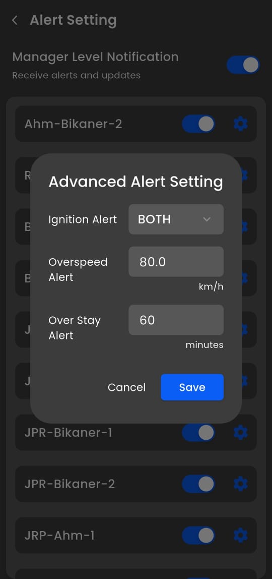
Customize real-time notifications for overspeed, geofence breaches, idle time, and maintenance reminders.
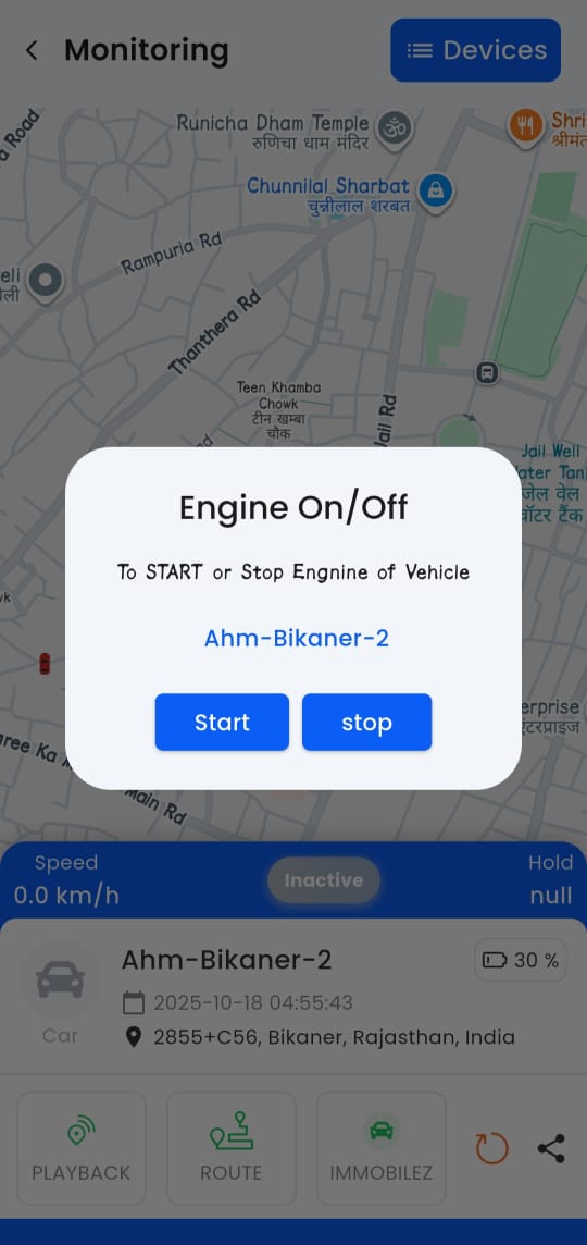
Live Monitoring
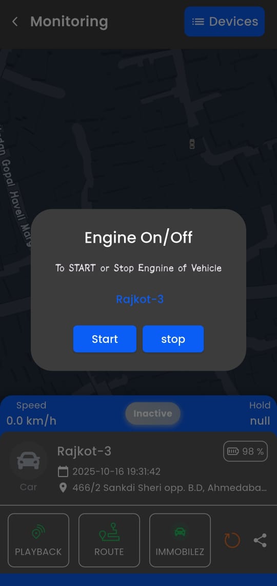
This feature enables remote engine control—allowing users to start or stop the engine of the vehicle "Ahm-Bikaner-2" from a distance. It serves as a critical security and emergency management tool in modern fleet tracking systems.
Playback Map View
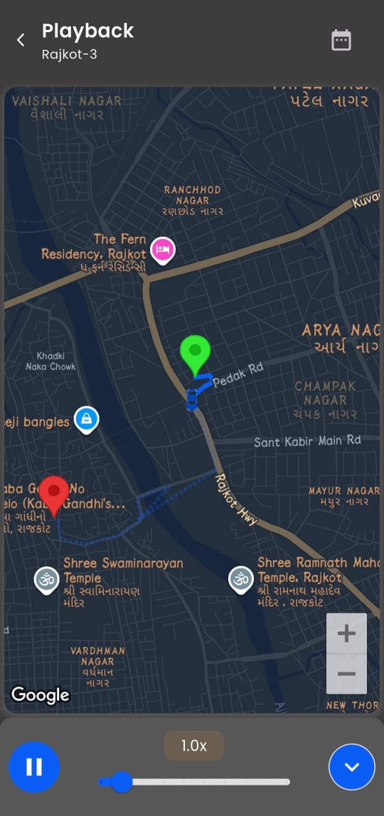
Animated route replay with 4.5x speed control for forensic analysis, driver review, and incident investigation.
Change Password
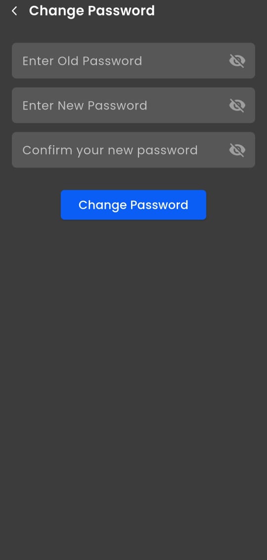
Secure interface for updating login credentials and maintaining account safety.
Vehicle Route History
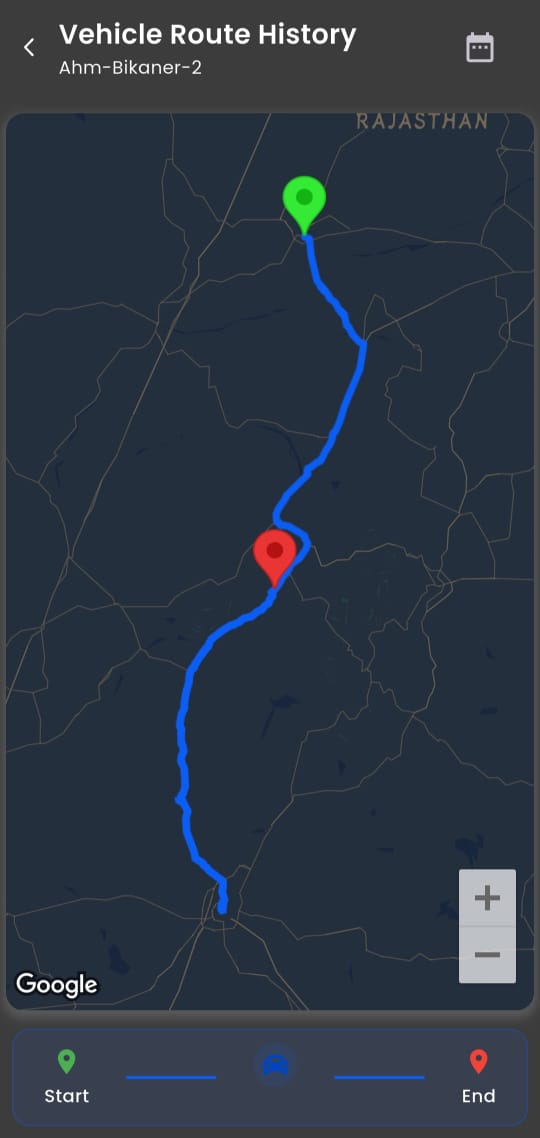
Detailed log of past journeys with timestamps and geographic coordinates for compliance and planning.
Trip Report
Breaks daily activity into individual trips with start/end locations, duration, and distance for logistics analysis.
POI History Report
Tracks time spent at predefined Points of Interest (e.g., Trikon Baug) to verify scheduled stops and client visits.
Speed Monitor Report
Logs average and peak speeds per segment with location tags (e.g., Sangariya) to enforce safety compliance.
Monitoring Dashboard
Real-time fleet status with live speed, location, and ignition data for immediate operational awareness.
Reports Hub
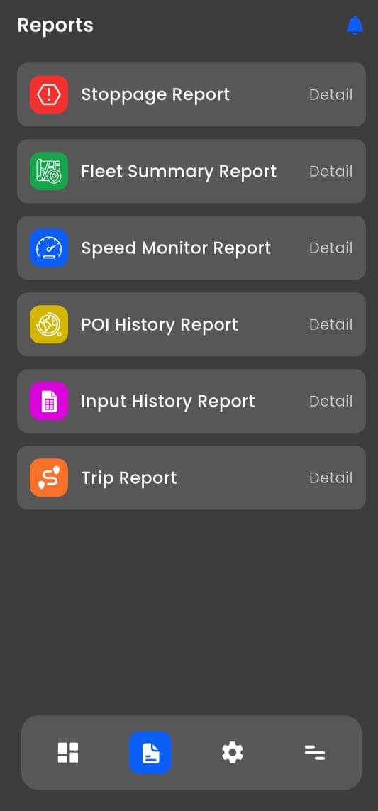
Centralized access to all analytical reports—stoppage, trip, speed, POI, and more—for data-driven decisions.
Stoppage Report
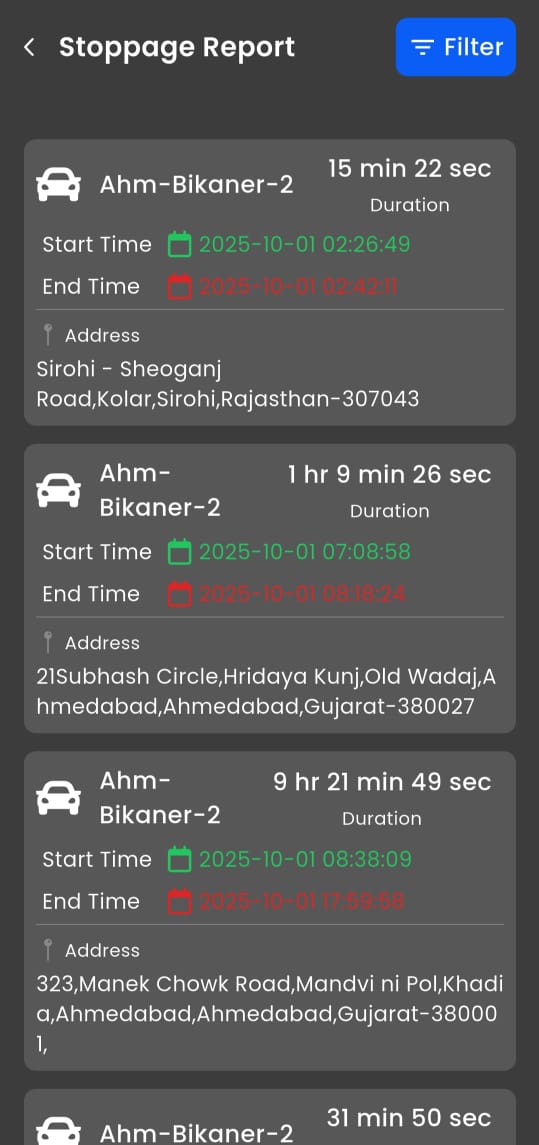
Chronological log of idle periods with exact addresses and durations to optimize efficiency and reduce waste.
Fleet Summary Report
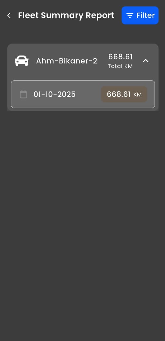
Daily mileage summary (e.g., 668.61 KM on 01-10-2025) for billing, maintenance scheduling, and utilization tracking.

Dashboard
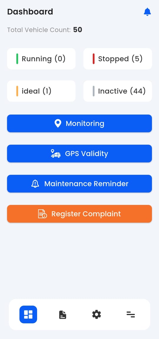
Overview of fleet status, active vehicles, and key performance indicators for quick operational insights.
Speed Monitor Report
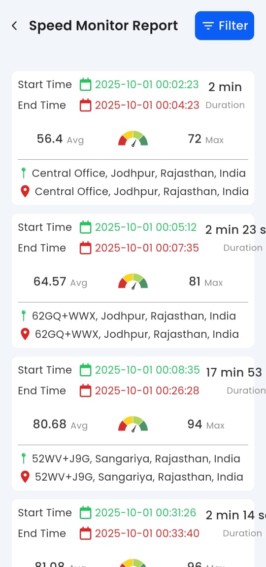
Detailed speed tracking with location tags to identify risky driving behavior and ensure compliance.
Playback Map View
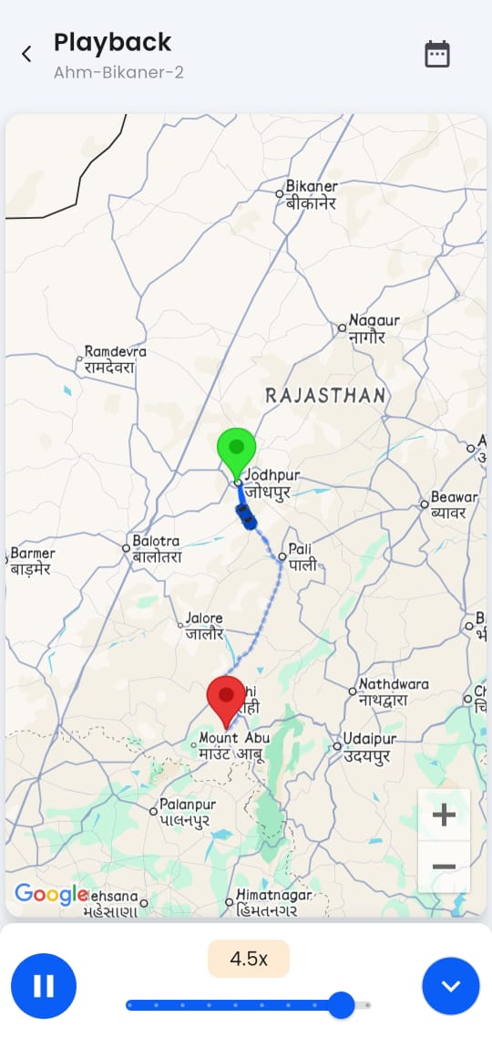
Animated replay of historical routes with adjustable speed for incident review and driver coaching.
Trip Report
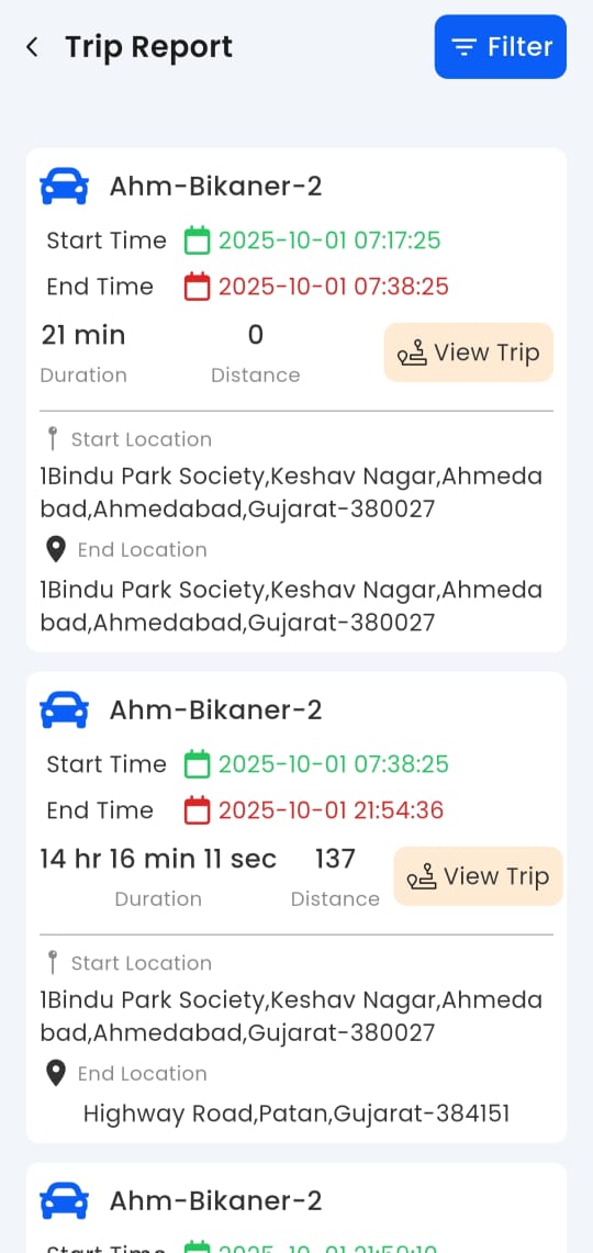
Breaks vehicle activity into individual trips with start/end points, distance, and duration for logistics optimization.
Live Monitoring
Real-time tracking of all vehicles on an interactive map with live speed, status, and location updates.
Stoppage Report
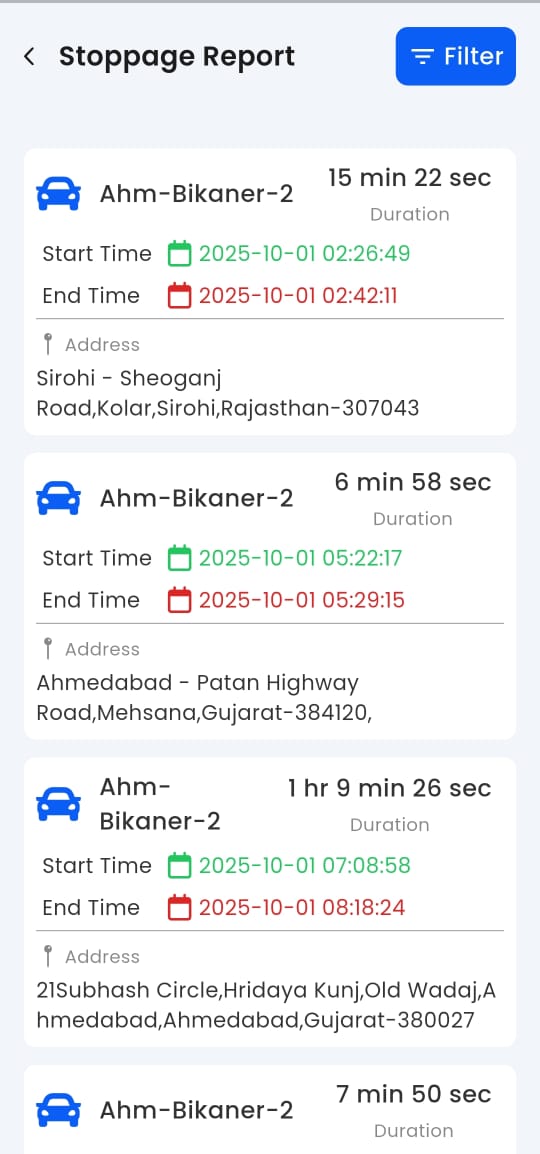
Logs all idle periods with exact addresses and durations to improve fleet utilization and reduce fuel waste.
Input History Report
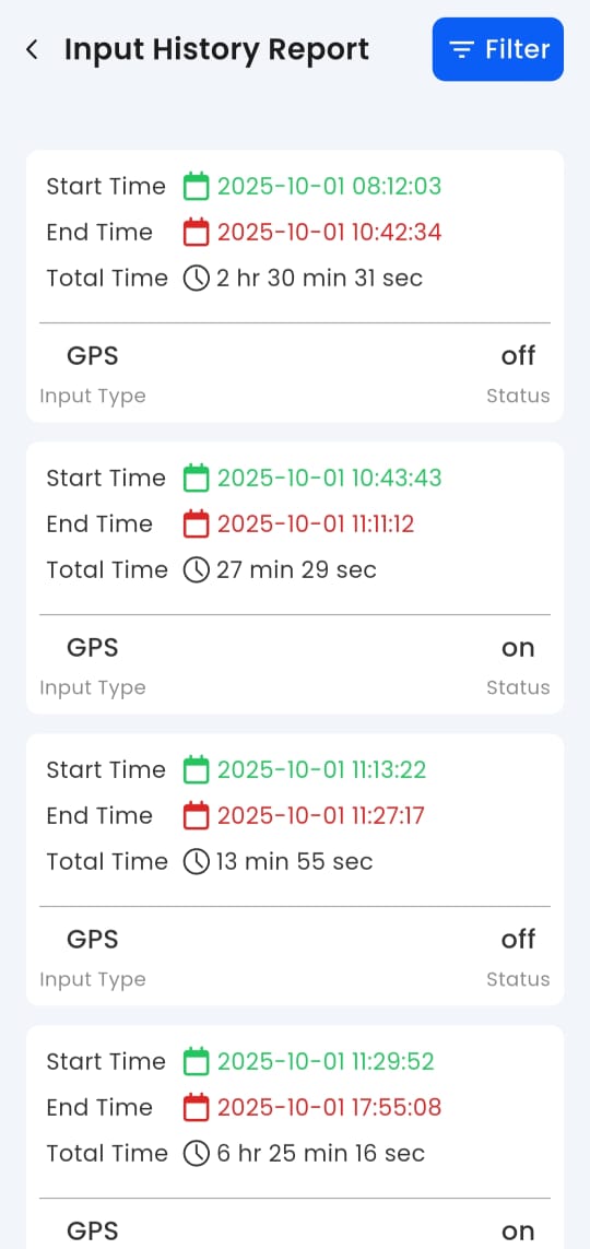
Tracks power and input status changes to detect tampering, disconnections, or device malfunctions.
POI History Report
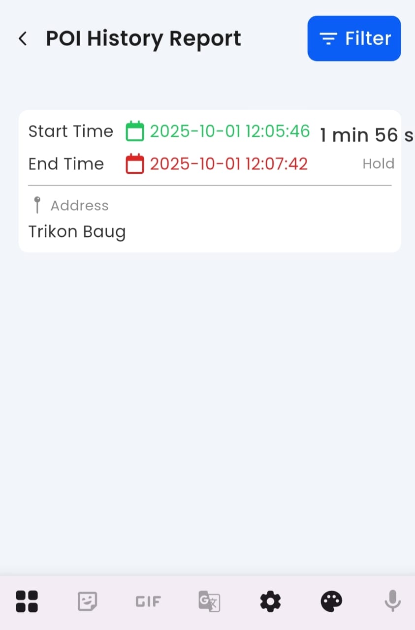
Monitors time spent at predefined Points of Interest to verify scheduled stops and customer visits.
Fleet Summary Report
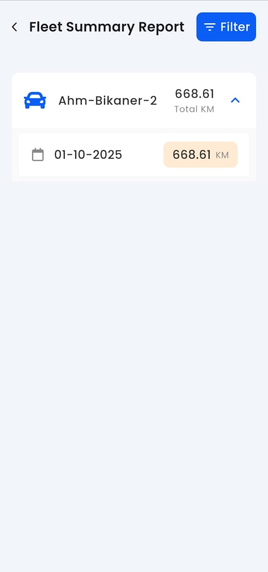
Daily or monthly summary of total distance traveled (e.g., 668.61 KM) for billing, maintenance, and efficiency analysis.
Vehicle Route History
Complete log of past journeys with timestamps and coordinates for audit, compliance, and route planning.
Alert Settings
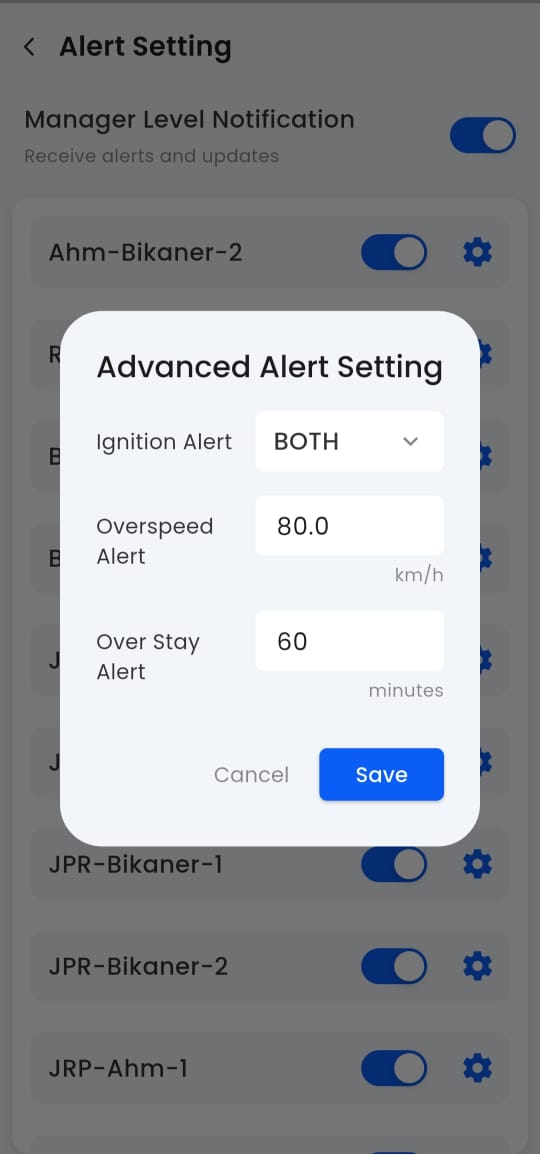
Configure real-time notifications for overspeeding, geofence breaches, idling, and maintenance alerts.
About Us
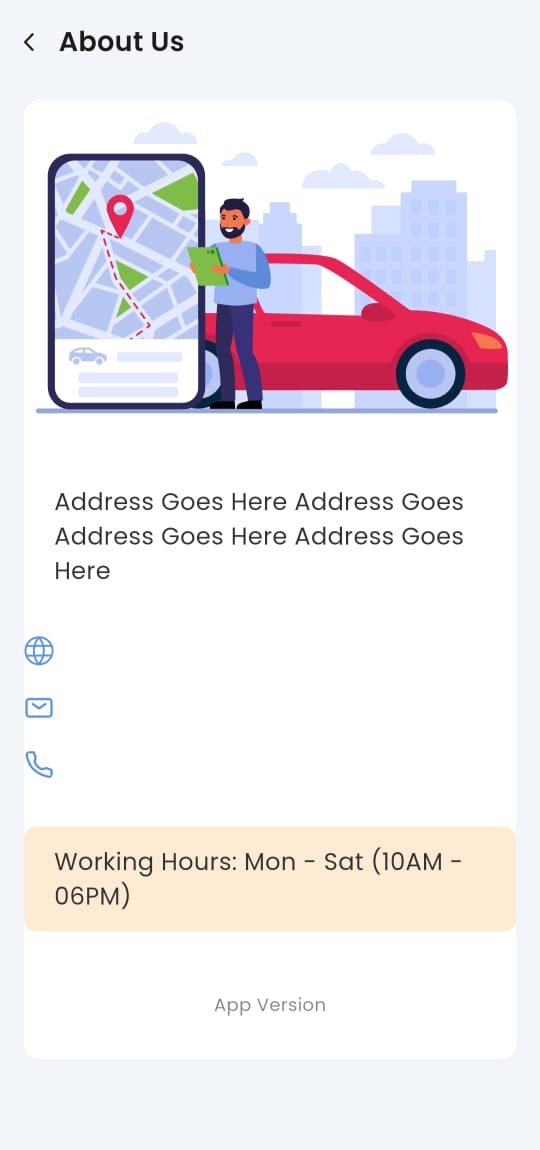
Displays company details, app version, and support contact information for user assistance and transparency.
Live Vehicle Tracking Mastery: Multi-Language Dashboards, Google Maps & Ola Maps | Bonrix GPS Solutions
Bonrix Software Systems: Revolutionizing Vehicle Tracking Solutions
Headquartered in Ahmedabad, Gujarat (India), Bonrix Software Systems is a leader in advanced vehicle tracking solutions, with a strong emphasis on intelligent, user-focused dashboard design. Their platforms provide real-time intelligence for fleet operators, logistics providers, and security teams—merging powerful functionality with an intuitive user experience.
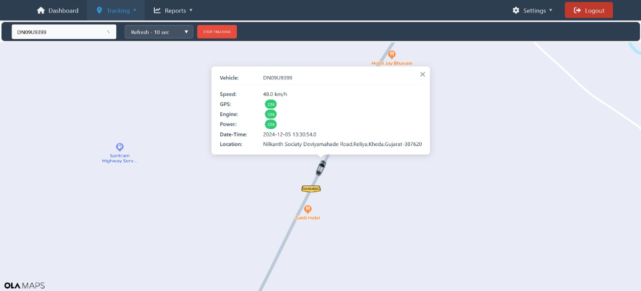
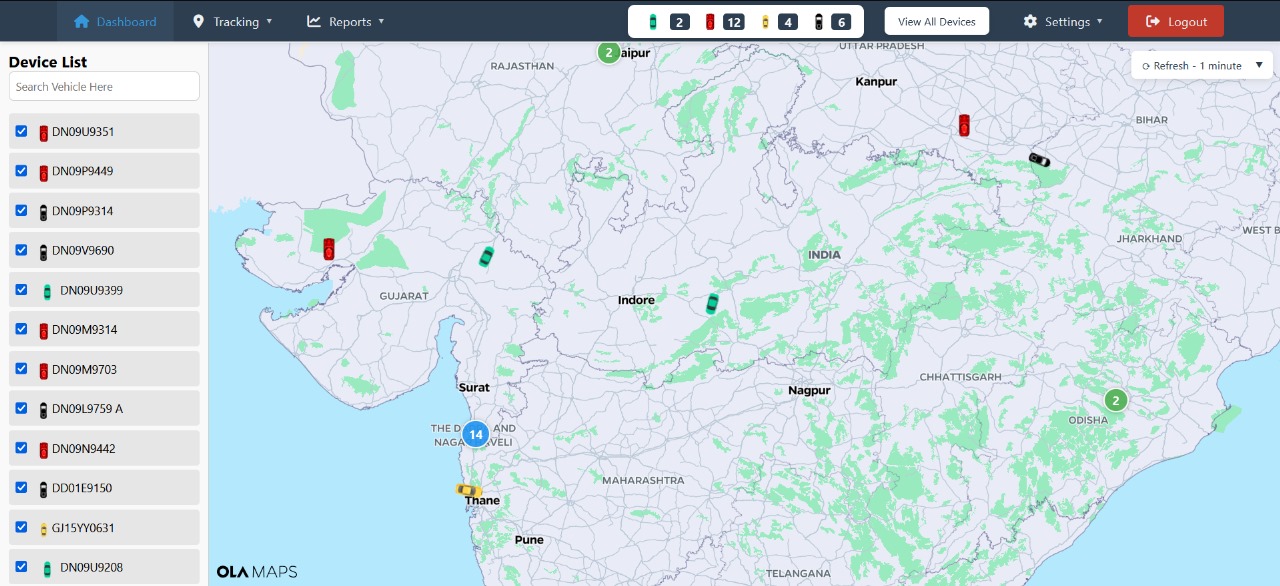
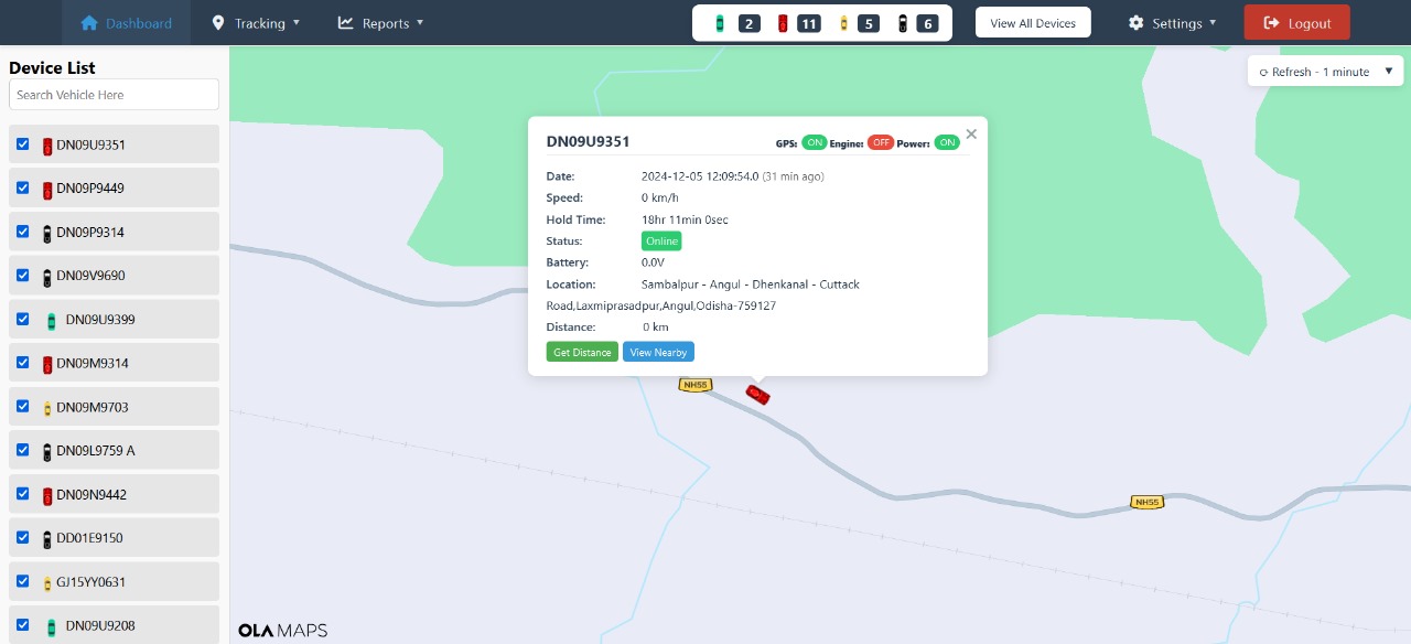
The Bonrix live tracking dashboard delivers immediate situational awareness through dynamic, real-time vehicle monitoring. Vehicles appear on interactive maps with continuous position updates, allowing managers to observe movements as they occur and maintain full operational transparency.
Users can adjust data refresh intervals—ranging from 10 to 60 seconds—to match their operational needs, ensuring optimal balance between tracking precision and network efficiency, whether for high-priority deliveries or standard fleet oversight.
The system supports multiple mapping services to accommodate varied user preferences and regional requirements. Google Maps offers global coverage with traffic insights and satellite views, MapmyIndia provides hyper-local accuracy tailored for Indian roads, and OlaMap delivers a cost-effective, routing-optimized alternative ideal for emerging markets.
To ensure accessibility across diverse user groups, the dashboard includes multilingual support. Interfaces can be displayed in languages such as English, Hindi, Gujarati, and more—making the system easy to use for drivers, field staff, and international partners alike.
Beyond location tracking, the dashboard presents a rich array of vehicle data. Live metrics include speed, ignition status, fuel levels, and engine diagnostics. Trip analytics cover distance covered, route deviations, idle duration, and estimated time of arrival. The system also issues instant alerts for events like geo-fence violations, overspeeding, or scheduled maintenance. Additionally, historical playback allows users to review past journeys for performance audits or route optimization.
Bonrix stands out through its commitment to flexibility and security. Dashboards can be customized for different user roles—dispatchers, drivers, or executives—while the underlying architecture scales effortlessly from small fleets to enterprises managing over 10,000 vehicles. All data is protected with end-to-end encryption and role-based access controls.
With Bonrix GPS Solutions, organizations gain more than just vehicle visibility—they gain actionable operational intelligence. This empowers smarter decision-making, enhances fleet safety, and drives superior logistics performance across every journey.
🚀 Bonrix Launches Smart Vehicle Dashboard | Multi-Map GPS, Multilingual, Weather & Analytics #gps
🚀 Bonrix Unveils Intelligent Vehicle Dashboard | Multi-Map GPS, Multilingual Support, Weather Insights & Advanced Analytics
Bonrix Software Systems is transforming vehicle tracking through innovation. Headquartered in Ahmedabad, Gujarat (India), the company is a trusted provider of cutting-edge IT solutions, combining technical excellence with a strong focus on client needs. With deep expertise in GPS tracking, mobile recharge systems, bulk SMS, AI/ML engineering, and fintech, Bonrix has launched a next-generation Vehicle Tracking Dashboard—marking a significant advancement in fleet and logistics management.
Engineered for real-time visibility and operational intelligence, this smart dashboard integrates advanced features tailored to the demands of modern logistics.
The Unified Fleet Overview gives instant access to the entire vehicle network. Whether managing a single delivery van or a large commercial fleet, users can monitor live locations, current statuses, and movement history from a single, intuitive interface.
Multi-Map Integration supports leading platforms such as Google Maps, OLA Maps, and MapMyIndia, ensuring accurate tracking across both urban and remote areas—perfectly suited to India’s varied terrain and regional navigation needs.
The dashboard also features multilingual support, breaking language barriers by offering interfaces in multiple Indian languages. This makes the system accessible and user-friendly for drivers, field staff, and managers nationwide.
Going beyond location tracking, the system delivers real-time vehicle telemetry—including fuel levels, engine status, and maintenance alerts—alongside live weather updates. This dual-layer insight helps prevent route disruptions, optimize journey planning, and enhance driver safety.
Advanced reporting and analytics capabilities allow businesses to generate customized insights on route efficiency, fuel consumption, driver behavior, and more. Historical data analysis supports smarter decision-making and long-term operational improvements.
Bonrix stands out through its commitment to agility, innovation, and future-ready technology. By leveraging IoT, cloud computing, and artificial intelligence, the company builds scalable solutions that evolve with its clients—spanning industries from logistics to fintech and digital commerce. This new dashboard reflects that vision, offering precision, ease of use, and enterprise-grade scalability for startups, SMEs, and large organizations alike.
Advanced GPS Tracking Application #automobile #tracking
Comprehensive GPS Tracking & Fleet Management Insights
This video provides an excellent demonstration of the various historical reporting and alert management features within a comprehensive GPS tracking system. It showcases the depth of data available for auditing fleet operations over a specific period, helping fleet managers optimize efficiency, safety, and accountability.
The video begins by showing a menu of detailed reports, including Stoppage Report, Fleet Summary Report, Speed Monitor Report, POI History Report, Input History Report, and Trip Report. This highlights the system's ability to categorize and present data based on different operational metrics—providing insights from driver behavior to vehicle performance.
The user then navigates to several reports, demonstrating the powerful search and filtering capabilities. For each report, the user selects a date range (specifically focusing on 01/10/2025), a specific device (e.g., “Rajkot-Ahm-2”), and report-specific criteria (e.g., “10 Min” stop duration for the Stoppage Report).
Stoppage Report: This report reveals multiple entries detailing the duration, start/end times, and exact addresses of vehicle stops—including a significant stop lasting 10 hr 43 min 43 sec. Such detailed visibility is vital for managing driver breaks, validating delivery and wait times, and improving route efficiency.
Fleet Summary Report: The Fleet Summary Report provides a clear calculation of the Total Distance traveled—showing 228.47 KM for the selected device on the chosen date. This data is critical for mileage tracking, fuel cost analysis, and performance benchmarking.
Speed Monitor Report: This feature demonstrates the system’s capability to configure a speed threshold (e.g., 40 km/h) to track and flag over-speeding events. It enables managers to maintain safety compliance and monitor driver discipline through automatic logging of speed violations.
Alert Management: The video concludes with the Alert Setting screen, showcasing how managers can configure and personalize real-time notifications. Alerts such as Overspeed (60.0 km/h) and Over Stay (30 minutes) can be set to trigger instant notifications—empowering proactive intervention to prevent violations or inefficiencies before they escalate.
Overall, the demonstration reinforces Bonrix’s dedication to delivering smart, data-driven GPS tracking technology—combining live monitoring, detailed analytics, and customizable alerts for seamless fleet management, safety assurance, and operational control.
Advanced gps Tracking Application
Real-Time Monitoring & Historical Playback in GPS Fleet Tracking
This video provides a detailed demonstration of the core functionalities within a fleet management and GPS tracking application, focusing on real-time status, live monitoring, and historical playback of a monitored vehicle.
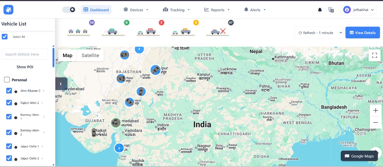
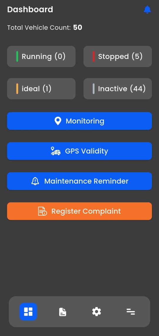
The sequence begins on the Dashboard (0:00–0:02), which offers an immediate, high-level overview of the entire fleet. It displays a Total Vehicle Count of 50 and categorizes their current operational status into Running (0), Stopped (4), Idle (1), and Inactive (45), giving managers an instant picture of overall fleet utilization and availability.
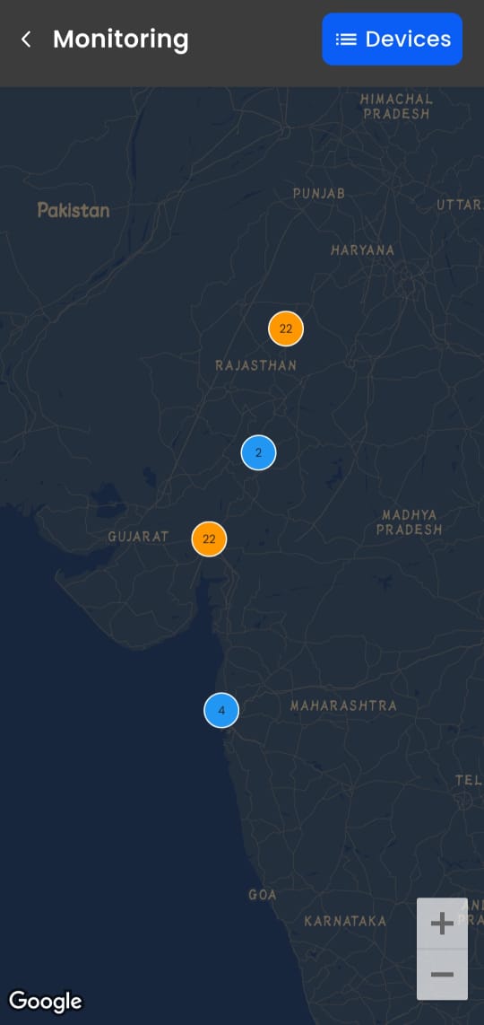
The video then transitions to the Live Monitoring feature (0:03–0:19), where a map view shows the real-time geographical location of vehicles scattered across a large area (parts of Gujarat and Rajasthan are visible). As the map loads and zooms in, a list of vehicles appears below, displaying their current status (e.g., 0.0 km/h, Inactive), last known location (such as Bikaner, Rajasthan), and the timestamp of the last report. This confirms the application’s ability to deliver minute-by-minute tracking updates and accurate positional data.
Next, the user demonstrates the Historical Playback function (0:20–1:26). Initially, the app displays an “Exception: No data available for the selected period” message, prompting the user to select a valid date range. Upon selecting a past date (October 1st, 2025), the system retrieves the vehicle’s complete trip history. The map updates to display a long-distance journey between Jodhpur and Mount Abu, clearly marked with start and end location pins.
The playback then begins, showcasing a smooth, animated visualization of the vehicle’s route. A panel beneath the map provides real-time analytics during playback: Current Speed fluctuates dynamically, reaching speeds up to 96.0 km/h and dropping to as low as 15.0 km/h, revealing driver speed behavior and road patterns. Total Points displays 1207 recorded GPS data points captured throughout the trip. Progress Counter tracks playback advancement, such as 16/50 → 212/500+, indicating how far the replay has progressed through the data stream.
The video highlights a 5.0x playback speed multiplier, showing that the trip is being reviewed at five times real speed—an invaluable feature for fleet audits, performance analysis, and training purposes.
Overall, this demonstration underscores the system’s comprehensive approach to fleet visibility, route auditing, and driver performance tracking. The historical playback capability enables companies to verify travel times, investigate incidents, assess compliance with speed regulations, and ensure operational transparency after every journey.
GPS tracking or fleet management system
Comprehensive Fleet Management Features Demonstrated
This video demonstrates the functionality of a GPS tracking or fleet management system, likely operating on a web-based platform. The interface prominently features interactive maps of India, particularly focusing on regions like Gujarat, Rajasthan, and the Delhi NCR area.
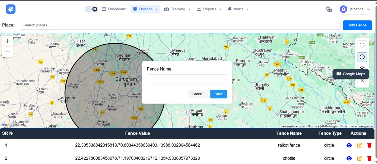
The video begins on a map showing a large area of India with multiple vehicle markers scattered across states, suggesting a wide fleet network. A helpful overlay prompts the user: “Use ctrl+scroll to zoom the map.” The user then accesses the “Tracking” menu, selecting “Vehicle Panel” followed by “Geo Fence.”
The map zooms into the Delhi/New Delhi region, where the user clicks near Greater Noida/Ghaziabad to place a pin and initiate Geo-Fence creation. A circular boundary is drawn, and a pop-up allows naming the Geo-Fence—in this case, simply labeled “d.” This feature enables virtual boundary monitoring for alerts on entry or exit.
Next, the user navigates to a “Device List” section displaying a table with device names, phone numbers, and precise GPS coordinates. This confirms the system’s ability to manage and retrieve detailed device metadata alongside location data.
The Route Playback function is then showcased: a blue line traces a vehicle’s historical path between two points, accompanied by a brief “Route Saved successfully” notification. Later, real-time vehicle status is displayed via a pop-up showing Speed, Ignition, Engine, and GPS indicators—providing immediate operational insight.
The user retrieves a past route by selecting specific dates and times, resulting in a visualized journey starting from Ahmedabad. Finally, the system demonstrates Point of Interest (POI) and Geo-Path management, where the user fills out a form to “Add Geo Path” with fields like “Select Driver,” “Start Location,” and “Geo Path Name”—highlighting the platform’s support for pre-planned route enforcement and compliance monitoring.
In summary, the video highlights a versatile web application for managing vehicle fleets, offering core features like live location tracking, historical route analysis, setting geographic boundaries (Geo-Fences), and managing route plans (Geo-Paths).